Methane
-
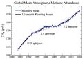
Atmospheric Methane
-
Atmospheric Methane doesn't correlate with cattle population


Satellites Put the World’s Biggest Methane Emitters on the Map
Bloombert Green By Naureen S Malik October 21, 2020
GHGSat Inc. released a new methane map on Wednesday that uses data from the company’s two satellites, which were launched earlier this year and can detect methane emitted by oil and gas wells, coal mines, power plants, farms and factories. It’s part of a wave of climate surveillance that will make it possible to hold countries and companies accountable for meeting targets to reduce and eventually eliminate planet-warming pollution.
Methane, explained
BY ALEJANDRA BORUNDA PUBLISHED JANUARY 23, 2019 <embed>https://www.nationalgeographic.com/environment/global-warming/methane/#:~:text=The%20effects%20aren't%20just,be%20attributed%20to%20the%20gas.</embed>
Cows and bogs release methane into the atmosphere, but it's by far mostly human activity that's driving up levels of this destructive greenhouse gas.
 But methane’s chemical shape is remarkably effective at trapping heat, which means that adding just a little more methane to the atmosphere can have big impacts on how much, and how quickly, the planet warms.
Methane is a simple gas, a single carbon atom with four arms of hydrogen atoms. Its time in the atmosphere is relatively fleeting compared to other greenhouse gases like CO2—any given methane molecule, once it’s spewed into the atmosphere, lasts about a decade before it's cycled out. That’s a blip compared to the centuries that a CO2 molecule can last floating above the surface of the planet. But there are many sources of methane, so the atmospheric load is constantly being regenerated—or increased.
